- News
- Reviews
- Bikes
- Components
- Bar tape & grips
- Bottom brackets
- Brake & gear cables
- Brake & STI levers
- Brake pads & spares
- Brakes
- Cassettes & freewheels
- Chains
- Chainsets & chainrings
- Derailleurs - front
- Derailleurs - rear
- Forks
- Gear levers & shifters
- Groupsets
- Handlebars & extensions
- Headsets
- Hubs
- Inner tubes
- Pedals
- Quick releases & skewers
- Saddles
- Seatposts
- Stems
- Wheels
- Tyres
- Tubeless valves
- Accessories
- Accessories - misc
- Computer mounts
- Bags
- Bar ends
- Bike bags & cases
- Bottle cages
- Bottles
- Cameras
- Car racks
- Child seats
- Computers
- Glasses
- GPS units
- Helmets
- Lights - front
- Lights - rear
- Lights - sets
- Locks
- Mirrors
- Mudguards
- Racks
- Pumps & CO2 inflators
- Puncture kits
- Reflectives
- Smart watches
- Stands and racks
- Trailers
- Clothing
- Health, fitness and nutrition
- Tools and workshop
- Miscellaneous
- Buyers Guides
- Features
- Forum
- Recommends
- Podcast
news
 Birmingham Top Tube Map
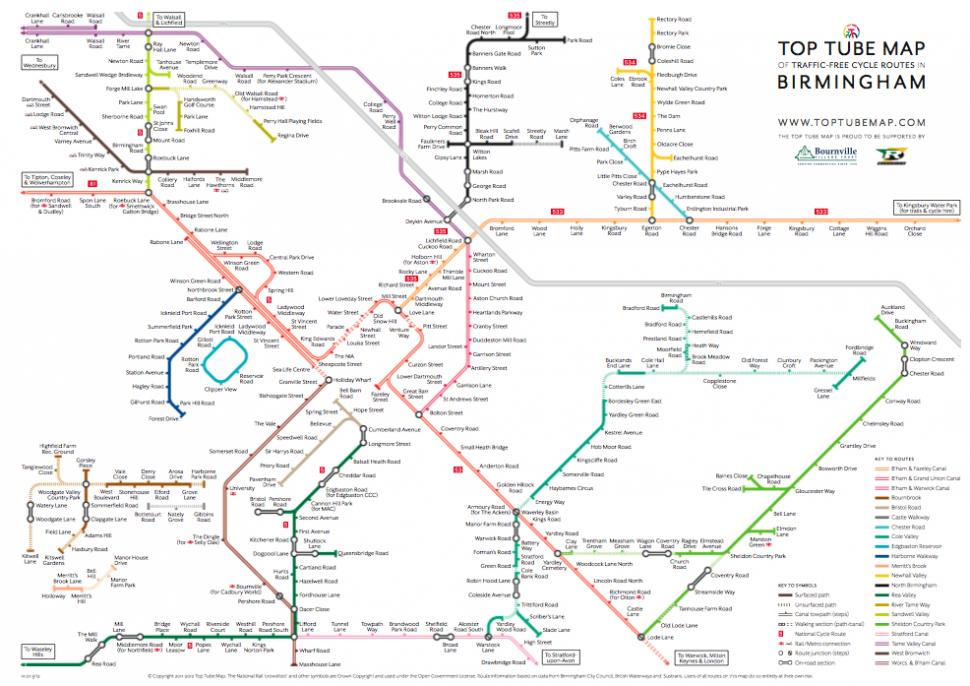
Top Tube Map charts Birmingham's traffic-free cycle routes
Cyclists living or working in Birmingham, or those visiting Britain's second-biggest city, now have an easy way of finding their way around on traffic-free routes with the official launch of the Top Tube Map, which shows the connections between 21 separate routes on a mixture of surfaced and unsurfaced paths, canal towpath, and short on road sections that sometimes link different routes.
It's clear that the design owes much to the iconic London Underground map devised by Harry Beck back in 1931, but Nick, the map's creator, also acknowledges as an inspiration the more recent Innertube map of Edinburgh launched last year by the Bike Station, and adds that it was compiled with the help of feedback from members of BirminghamCyclist.com.
Sources used in compilng the Top Tube map, which has been a year in the planning, include Birmingham City Council and its own Walking and Cycling Map, as well as information from Sustrans and British Waterways.
The map, downloadable from the Top Tube Map website where you can also find more information about the project, was produced with the financial help of two local enterprises.
One is Bournville Village Trust, originally founded by George Cadbury in 1900 to provide model housing for workers at his family's chocolate factory and now a housing association responsible for some 8,000 properties in Brimingham and beyond, while the other is steel tubing maker Reynolds, originally founded in the city as a nailmaker in 1841, and still headquartered there today.
Latest Comments
- matty1980 9 sec ago
Also - say your employer is small they may want to look into a financed scheme - the company will get the voucher issued to you and then pay in...
- David9694 24 min 13 sec ago
Driver taken to hospital after flipped car shut road near Barnstaple...
- chrisonabike 40 min 41 sec ago
Fortunately for the driver he owned a basenji! No comment...
- chrisonabike 1 hour 17 min ago
Is it a catchy but meaningless hook from a European song contest runner up of yore?...
- a1white 1 hour 25 min ago
Yes, I've had this same light for years. It works well and is reliable, but it's a few years old now.
- andystow 1 hour 33 min ago
A bargain at under £72 per watt!
- Surreyrider 1 hour 52 min ago
Our policing and legal systems are based on witnesses, apart from when it comes to driving apparently.
- mdavidford 3 hours 42 min ago
It looks like it would give you more of a sideways elliptical motion - like a cross-trainer - rather than the up-and-down of the Alenax.
- wtjs 3 hours 59 min ago
They've only got two wheels on the road, so it doesn't count as parking in the road...
Add new comment
3 comments
Many thanks for the article, Simon. Really appreciated. Just to say that if your readers want to download the map they can get if for free from http://toptubemap.com
Cheers,
Nick.
I got lost cycle-touring through Birmingham just last month trying to stay off-road. I welcome the map, but I do have two concerns:
1)Signage shouldn’t be poor enough to require (very) frequent map checking to be necessary.
2)The map looks to suffer from the same problem as the few signs on such routes; they are hopelessly local. Labelled destinations and access point names mean nothing to anyone from beyond the local suburb. There’s no equivalent of road signs saying “The North Stafford” and “The South Birmingham” as are on the M6 in the area.
Hello Vin,
Thanks for taking the time to comment. You raise some interesting points. I don't think you can get away from the stop labels on the map being local, but I understand what you mean about having more contextual information to help you navigate.
One of the experiments that I've been meaning to investigate for ages is adding more place information to the map e.g Edgbaston, Sutton etc. to help better orient users. Now that the base map's complete and the web version's up and running I can try these kinds of things out relatively easily.
As far as signage goes, that's out of my hands at the moment. I am (along with a couple of other interested people) looking at options for raising funds to allow the installation of Top Tube-specific signs. I've done some brief sketches that include local directions as well as contextual 'you-are-here' markers on the route as a whole. Your road sign equivalents could be a great addition to those.
Cheers,
Nick.